 Thursday 05 February 2026 22:37
Trevico
| Condividi |

|

|

|

|
The medieval town |
Port'Alba |
The War Memorial |
The Castle
The Cathedral SS. Maria Assunta | The Crypt | The Church of Addolorata
The Church of St. Rocco | The Church of St. Vito | The Church of St. Lucia and St. Euplio
The Church of Sacred Heart | The Church of Madonna of Fatima
Palace Calabrese | Palace Scola
The Cathedral SS. Maria Assunta | The Crypt | The Church of Addolorata
The Church of St. Rocco | The Church of St. Vito | The Church of St. Lucia and St. Euplio
The Church of Sacred Heart | The Church of Madonna of Fatima
Palace Calabrese | Palace Scola
The medieval town
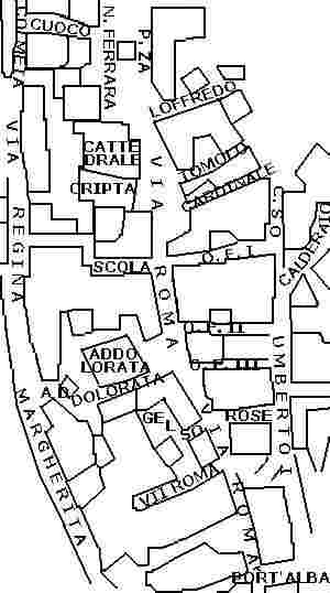 The urban structure of Trevico reflects the typology of the medieval city where the central street axis, Via Roma,
starts from the gateway to the city, Port'Alba, following towards the central square where is located the Cathedral and the
noble palaces and proceeds towards the Castle located in the highest part of the country (1094 mt. above sea level.). From the main street
that longitudinally crosses the agglomeration, branch out numerous alleys that, for defensive reasons, connecting it with
the city walls that once surrounded it.
The urban structure of Trevico reflects the typology of the medieval city where the central street axis, Via Roma,
starts from the gateway to the city, Port'Alba, following towards the central square where is located the Cathedral and the
noble palaces and proceeds towards the Castle located in the highest part of the country (1094 mt. above sea level.). From the main street
that longitudinally crosses the agglomeration, branch out numerous alleys that, for defensive reasons, connecting it with
the city walls that once surrounded it.
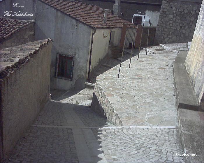
The alleys are, starting from Port'Albato the left Vico VII Roma and Vico Gelso which are closed; Vico Addolorata and Vico Scola descending on V. Regina Margherita; on the right Vico delle Rose, Vico O. Flacco III, II, I, Vico Cardinale that bring all of C.so Umberto I; Vico del Tomolo e Vico Loffredo which are closed. Finally, the Rampa Cuoco that descends from P.za N. Ferrara towards V. Colmeta. In addition from C.so Umberto I branch off two flights Costa Calderaio that descend towards Via Forragine.
The medieval town |
Port'Alba |
The War Memorial |
The Castle
The Cathedral SS. Maria Assunta | The Crypt | The Church of Addolorata
The Church of St. Rocco | The Church of St. Vito | The Church of St. Lucia and St. Euplio
The Church of Sacred Heart | The Church of Madonna of Fatima
Palace Calabrese | Palace Scola
The Cathedral SS. Maria Assunta | The Crypt | The Church of Addolorata
The Church of St. Rocco | The Church of St. Vito | The Church of St. Lucia and St. Euplio
The Church of Sacred Heart | The Church of Madonna of Fatima
Palace Calabrese | Palace Scola
Contact | Copyright | Privacy Policy
